
One of these days I'm going to figure the right way to hike the Nootka Trail.
It hasn't happened yet. It's an interesting little trail that runs the outer length of Nootka Island from Louie Bay on the northwest to the old village site of Yuquot on the southeast. It's about 36 km depending on where you start and how you measure the twists and turns. That and the extent of the beach make it one of the less demanding coastal hikes in British Columbia, but if you know British Columbia coastal hikes, you'll know that doesn't necessarily mean it is easy.

There are the rough beaches where you have to jump from boulder to boulder. There are the rough bypasses where you have to scramble up bluffs and disappear into thick forest cover. There are the crunching beaches, where each footfall means double the effort per step to compensate for the lost ground caused by sliding pebbles.

But most of all the Nootka Trail is about logistics. It's on an island, after all. So you can water taxi in, paddle in or fly in or take the Uchuck passenger freighter service out of Gold River. I would have tried that this last visit, but it was booked up, so there would be no escaping the island that way. That left us the option of a water taxi, and so Tahsis became our starting point and point of return.
This was to be my fifth visit along the outer coast of Nootka. The first time was a paddle down the outside of Nootka Island in the summer of 2003. It was a beautiful morning on the coast until a line of white came nearer and nearer. Then, when fully engulfed in thick fog, my rudder cable snapped. That meant the northwest swell knocked me askew by about 30 degrees from the stern with every wave. With the constant turning I was unable to keep course by keeping sight of land. From there on I heard Nootka Island more than I saw it, and that's how I navigated. By sound.
I kayaked it again one time as part of a longer trip in unseasonably high surf and paid the price. I circumnavigated Nootka Island on another occasion, and had previously hiked the trail once. That taught me it could be done in three nights if you plan it right. And I thought I did this time around.
I didn't.

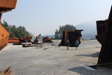
It begins with the water taxi (we used Shorebird Expeditions -- excellent service). Sure, you can depart early enough, but only if you plan to overnight at Tahsis. We didn't. Instead we drove up-island and met our water taxi captain mid-morning. From there it was a bumpy trip through Nuchatlitz Marine Provincial Park to Louie Bay. It was low tide, which helps because you can walk more of the mudflat than high tide, but regardless it's a mucky start to the day. The most interesting part is possibly the old freighter, intended to be carved up here for scrap in a venture that went astray (as have the ship's pieces).
Eventually Louie Bay narrows until it is just a narrow rock storm channel, and it requires careful navigation to figure out where to depart that channel to join the true trailhead for the first overland portion before Third Beach. Having been here before, I knew it was at the very end of the channel near the outer shore. But the tide was in and the climb across the storm channel daunting. Was there maybe an alternative way up a rope we had seen earlier on? Or was that just garbage left hanging on a cliff? Hard to say till we threw caution to the wind, scaled the cliff and ended up on the rock ledge outside the trailhead. Success. For the moment.

The question became what went wrong from here. The day literally vanished. We pushed, climbed, clambered and generally fought our way along the shoreline to the first major target, Third Beach.
Now those with more time on their hands and the leisure of arriving by plane will love Third Beach. And they do. Those arriving by plane will be dropped in at the lagoon, not the far side of Louie Bay, and so have only a short walk to get to Third Beach. Our hike was anything but easy. We showed up already battle-weary, tired and late in the day. Could we really have taken that long?

Worse, the next headland looked blocked by the higher tide. I went to explore and look for the bypass, pushing up a rough trail that zigged, zagged and went nowhere. I had no memory of a problem here. How could I be put out this early?
Not to worry. Third Beach was a beautiful spot. We had two more nights. I figured we could do the bulk of the trail over the next two days. Nothing to worry about, so instead of pushing on through the scrub we stayed put and enjoyed an incredibly relaxing evening watching the sun set.

Well, the effort of the previous day searching for the bypass was time wasted, it turned out. The trail actually went inland behind a lagoon away from shore, so no need to scale the bluff or wait for a low tide that seemed to have no intention of providing a path around the headland. Lesson learned. And we were off eager to make up the miles lost yesterday.
Well, the truth is you don't make up miles on a long coastal hike. You just push on as best you can.

And push on we did. We were troopers, with an occasional trooper break. We rounded Skuna Bay with nary a hiccup in our plans. Timing was on our side -- the morning tide was low and staying low through the day so we would have good beach access the entire way. No need for pesky overland bypasses. No need to hug the shoreline when better, more solid footing was available in the exposed intertidal area. With apologies to some snails, of course. We tried our best. But there was the inevitable crunch or two. Oh dear.

Salvation came by way of Calvin Falls. It's always the visual highlight of the outer coast, even when down to a late-summer drizzle of a flow. We might have camped here the first night had things started more smoothly. But instead it was lunch and a quick swim then back on the trail to make up the time we lost the day before. Penance Nootka Trail style.

It's a stretch to describe it as a trail at this point. It's really just a beach hike. With all kinds of beach. Sand, pebbles, rocks, boulders, rock flats... Even seaweed sludge. Don't mind the flies.
We rounded Bajo Point and found a nice level area further down a ways to set up camp. It was a long day, probably half the full length of the trail in one go. Dinner wasn't much, just stuff heated from packs. It was delicious.

The beach runs out for a while at Maquinna Point when the trail turns overland. It also makes that transition in the most dramatic way. There's a gully. Then a cliff. And a rope. Use one to overcome the other. About as simple as life gets. And precarious.

The overland portion is a highlight, to be sure. Grand forests. Viewpoints over dramatic rocky shore. Caves amid pocket beaches. You work for it though. Lots of elevation gain and loss. Lots of scrambles and climbs. It will tucker you out, to be sure.
But it's worth it.
When you exit the overland, you come out to a wonderful beach where you'll get a look at Yuquot in the distance with the lighthouse or old church visible if you're lucky.
It just becomes a matter of timing again. It didn't work for us. Again.
You see, just outside of Yuquot is a tidal lagoon. At high tide, it's deep with a current and waves and not the type of thing you can cross with a backpack.
Naturally, we arrived at high tide.
Worse, We couldn't wait it out because low tide was in the middle of the night. High tide was in the morning, and we needed to be in Yuquot early to catch our water taxi first-thing.
We were going to have to wait till dark, then cross in the night. Then find a camping spot. Yeeks.
So we had dinner. And waited. And waited. Testing the depth every so often by wading in. Then waiting more.
There was a trick apparently. A sand bar that was shallow. It ran at an angle at a certain distance out. You just couldn't see it, so you walked until it was too deep.
Then I found it. Waist deep across. It could be done. We wrestled packs on, laughing as waves sloshed us. But we made it. It was a grand triumph, and we hardly felt tired trudging more beach to find a campsite.

We found it. The perfect one between some rocks sheltering a level area on the gravel behind. We left it the next morning to a wonderful sunrise, arriving in Yuquot with enough time to explore the historic church and the grounds of the village area, as well as the old graveyard. An interesting place to be sure.

So we made it. But we sure worked hard for it. I think maybe the answer is to plan the trip to give yourself enough time so you don't have to push yourself. Just relax and enjoy. Maybe when I can do that, I'll have finally figured out how to master the Nootka Trail.
- John Kimantas, along with Holly and Allie
If you would like more details about the places named in this article and the Nootka Trail, be sure to get a copy of the Nootka Trail map by Wild Coast Publishing, or BC Coast Explorer Volume 1.
