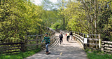
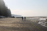
Victoria's Capital Regional District has been embarking on an ambitious quest to create what it is calling a Sea to Sea Green Blue Belt, a corridor of protected green space from Saanich Inlet in the east to Juan de Fuca Strait in the west. The job was already partially done thanks to Goldstream Provincial Park and the Greater Victoria Water Supply Area, but the Sea to Sea Regional Park Reserve adds considerably to that, with Sooke Mountain Provincial Park between them and Sooke Hills Regional Park Reserve abutting it to the east. It will eventually have a system of designated hiking, mountain biking and equestrian trails through terrain varying from small pockets of old-growth forest and wetlands to the viewpoints atop Mount Manuel Quimper and along the ridgeline of Monument Mountain. Most of the trails currently existing can be reached from Harbour View Road off Sooke Road. A few are shown in the detail map on page xx that extend as far as Grass Lake, but check online resources for additions if you wish to travel farther afield.
Explore Sooke: Sea to Sea Regional Park

Sooke Mountain Provincial Park: This is an undeveloped park and one of the earliest created on Vancouver Island, in 1928. It has rocky hills, forests, lakes and potential for recreation, including hiking, fishing and horseback riding, but with no maintained facilities. Mountain bikers can use the multitude of trails in the neighbouring Sea to Sea Regional Park Reserve. Backcountry wilderness camping is permitted year-round within the provincial park.
Sooke Hills Wilderness Park Reserve: This huge wilderness reserve protects a vast portion of the Sooke Hills between Saanich Inlet and Sooke Basin. The reserve protects 4,103 hectares and is the largest park in the region. It is a true wilderness park: no access is allowed, as it is a buffer for the Greater Victoria water supply. But wait! Read on.
Sooke Hills Wilderness Trail: The challenge was how to connect Victoria to the rest of Vancouver Island as part of the Trans Canada Trail as the only existing route, the major highway that is the Malahat Drive, was sorely unsuited to trail use. The logical solution was to use the reserve land to the west, which meant violating their restriction of no access to protect the Victoria water supply. In the end it was agreed that hikers probably aren't a threat after all, so the decision was made to create the 13-km Sooke Hills Wilderness Trail as part of the Trans Canada Trail, thereby connecting the Galloping Goose Regional Trail to the Cowichan Valley Trail.
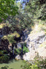
Mount Wells: This 123-hectare park is part of the lower east side side of the blue belt known for its spring wildflower displays and a few unusual residents, such as alligator lizards, which you may see sunning on the rocks on a warm day. The main feature is a steep but short (20-minute) 1.3-km trail leading from the parking lot to the summit of Mount Wells (352 metres). It crosses through Douglas-fir and arbutus forests to a wonderfully scenic viewpoint atop the rock bluff and meadow summit. Other casual trails criss-cross the area. Rock climbing is possible on the mount’s west face. The trail access is off Humpback Road.